Calm Before
Going into the arrival of the 7 of 10 scenarios predicted to occur before the end of 2010, all looks calm!
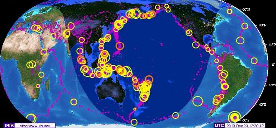
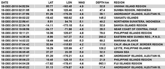
At least this was the case on December 20, 2010. In fact, half way through December 20, 2010, UTC
time, the live seismographs were dead calm except for a bit of magma sloshing. The IRIS chart showed
no new quakes over magnitude 4.0. On this IRIS chart, below, all recent quakes are in orange, a day
late, not red as same-day quakes are shown. No quakes magnitude 4.0 or greater, had occurred since
December 19, a full 13 hour absence.

Could this be a cover-up, in anticipation of the arrival of the 7 of 10 scenarios? The live seismograph
can be dialed down to be less sensitive, and this has been done several times since the arrival of Planet
X in 2003. Certainly quakes can be kept from the databases. The USGS dominates the world scene in
this regard, and has been caught deleting quakes and reducing the magnitude of quakes many times since
2003. But could this just be a calm before the storm?
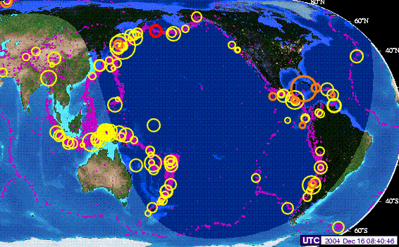
Lets compare to a December several years ago, prior to the big 9.5 quake in Sumatra on December 26,
2004. Note that on December 16, 2004, before the dual magnitude 8 quakes in Tasmania on December
23, and before the massive 9.5 quake in Sumatra on December 26 - things were very calm! The quakes
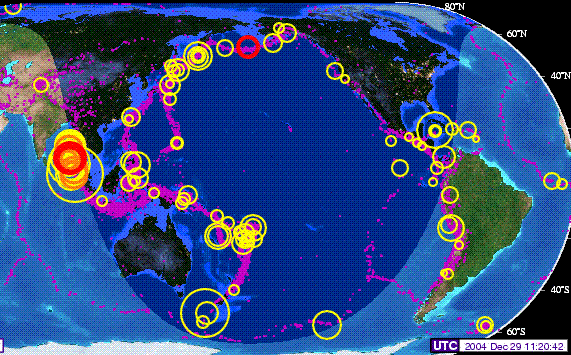
are in orange, not red, except for a small quake on the Aleutian Islands which is in red. Yet days later,
the big one hit, as shown on the December 29, 2004 IRIS chart.
The Zetas likewise indicated that as the tongue starts to slide under the curve of the Indo-Australian
Plate, that volcanic activity would be reduced in Sumatra and Java, because the magma could flow
along and not be caught in pockets.
ZetaTalk Explanation 10/23/2010: Will Krakatoa erupt, giving warning that the bending of the
tongue holding Indonesia is about to begin? Surprisingly, the nervous volcanoes in Indonesia will
not increase their eruption much beyond where they are today, during the elevation drop. The
reason is because the pressure of plate movement is going elsewhere, in a different direction.
Volcanoes erupt because magma is pushed into pockets near the surface, without an opportunity
to escape into the general flow of magma that takes place under the plates. Rather than
compress the tongue holding Indonesia, the dropping of the tongue allows this tongue to expand,
to fan out under the curve of the Indo-Australian Plate. At the present time, the pockets under
this edge of the tongue are increasingly compressed, thus the increased activity noted in
Indonesian volcanoes recently.
Krakatoa did erupt, briefly, just after Obama's nervous visit to the region, but settled down promptly
after that, as did the violently erupting Merapi volcano which chased Obama out of Jakarta early during
his visit. In fact, volcanic activity has calmed down in Indonesia! In Issue 210 of this newsletter, on
November 7, 2010 we noted that there were 21 volcanoes on alert, the highest number ever. Yet there
are only 5 active volcanoes at present, per RSOE - Semeru, Batu Tara, Ibu, Dukono, and the Barren
Islands (just north of Sumatra).

Thus, with reduced volcanic activity, per the Zetas there will be no certain predictor to warn mankind
that the start of the 7 of 10 scenario in Indonesia, the steady sinking, is about to begin.
ZetaTalk Prediction 10/16/2010: There is no predictor indicating that the bend and drop are
about to happen that we could point to. There are, as we mentioned there would be, indicators of
the direction that the plates are being pushed, as Jakarta has been sinking, Pakistan sinking, and
the Coral Sea floor rising. We are telling you your coastlines are not safe, and the rest is up to
you!
Christmas Hammer
The Christmas Hammer started on December 20, 2010 with massive global shuddering at
approximately 18:00 UTC, when the magnetic N Pole of Earth comes up over the horizon to face the
approaching Planet X. For several days in a row (December 20, 21, 22, and 23) the hammer struck.
Per the Zetas, 18:00 UTC is also when Planet X is positioned overhead, above the point where the
Indo-Australia Plate is lifting and being driven under the Himalayas. It is thus positioned over Indonesia,
where sinking is expected to start the 7 of 10 scenarios.

ZetaTalk Explanation 9/11/2010: The twice-a-day shudder - when the Atlantic Rift is facing
Planet X at 12 UTC and later at 0 UTC when it is in opposition on the other side of the globe - is
still present. Since the Atlantic Rift runs from Iceland to South Africa, this involves a tug that
affects the entire globe. The daily Figure 8 roll caused by the N Pole of Earth being pushed away
when it comes over the horizon continues. This occurs when Planet X is facing the central Pacific
at 18 UTC and as would be expected hammers at the brake point near the Solomon Islands. At 3
UTC a similar point is reached when the N Pole of Earth is hidden behind the horizon so the
globe can bounce back. But in addition to the Atlantic Rift tug and the N Pole push and rebound
there is also stress on the globe from Earth glancing off the magnetic field of Planet X. This is
not the temporary tug or the back and forth shove but a sudden flip to the side into a temporary
lean to the left or opposition. As is known, there is a magnetic anomaly just to the west of South
Africa, which acts almost like a second S Pole for Earth and is positioned on the other side of the
Earth at the same latitude from the Earth's magnetic S Pole. The N Pole of Planet X grabs this
anomaly, as it is a type of S Pole, thus lurching plates nearby. Chile had a quake during this 8
UTC time period.
During one of these hammer blows, a significant quake off shore from Japan in the Bonin Arc region
occurred. At first called a magnitude 7.9, this was later downgraded, as usual, by the USGS to be a 7.4.
The tsunami that followed did not cause the high tides and choppy waves noted throughout Indonesia
and in Australia and New Zealand, however, as the tsunami for this Bonin Arc quake progressed
northwest. The Bonin Arc is part of what is called the Izu-Bonin-Mariana arc, along the eastern edge of
the Philippine Plate as it approaches the point where 3 plates meet at Mt Fiji - the Philippine Plate, the
Pacific Plate, and the N American Plate. From the start of the Bonin Island hammering on December
20, 2010 at 17:19 UTC until December 24, 2010 at 10:05 UTC there were 101 quakes above
magnitude 4.7 in this hammer. And still ongoing.
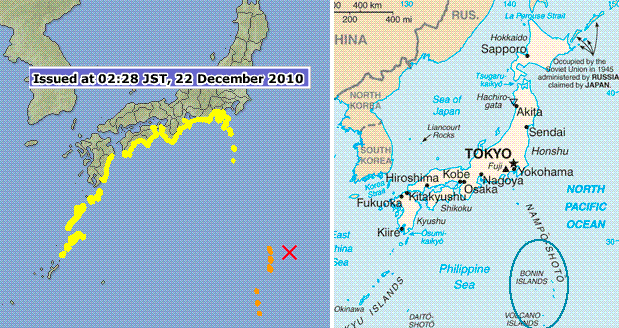
- Northeastern Japan arc
http://en.wikipedia.org/wiki/Northeastern_Japan_Arc
- Mount Fuji is at the point where these three arcs meet.
Media Silence
In nervous anticipation of the 7 of 10 scenario in Indonesia predicted to arrive by the end of 2010, the
Zetas were asked if the matter would be downplayed by the media, or how it would play out. Their
response was to explain that Indonesia would sink in spurts over a 2-3 week period, with the S America
roll scenario starting shortly after Indonesia's sinking begins.
ZetaTalk Prediction 12/18/2010: The 7 of 10 will unfold but not as expected by many. It will not
be a dramatic announcement on the news, as the establishment is ready for this, due to the
extensive discussions. As we stated, there would be large quakes when Indonesia sinks but not
the major quakes one would expect, not magnitude 8-9. Already there are many periods when
quakes line the plate borders, and hammer there. During one such episode, the elevation will
start to drop. We have never stated, in our predictions, how fast this would go, just said
"suddenly". The start will be sudden, almost without warning, but the progress not swift as in the
pole shift hour. It will be a steady sinking, in short bursts, over a 2-3 week period. S America will
be right behind Indonesia in this regard, starting its roll. This will start slowly at first, the trend
already noted, but the quakes starting to pick up as Indonesia sinks. Thus it will not be before the
early part of 2011 before the full impact of the prediction accuracy is noted by the world.
Meanwhile, the establishment will try to cover with lots of talk about storm surge, Global
Warming, and high tides.
A careful check of prior ZetaTalk shows that where they stated the 7 of 10 scenarios would arrive by
the end of 2010, they did not specifically state that "shocking the world" would happen by the end of
2010.
ZetaTalk Prediction 7/19/2010: We were only allowed to state that one or more of the plate
movements described would happen by the end of 2010, when a 7 of 10 would have arrived, and
that a 7 of 10 would "shock the world" so that there would be no doubt it had arrived.
ZetaTalk Prediction 7/31/2010: Our statement is that a 7 of 10 would "shock the world" and be
unmistakable. At least one of them will occur before the end of 2010.
ZetaTalk Prediction 8/7/2010: Our prediction that a 7 of 10 will occur by the end of 2010, and
will "shock the world".
With a 2-3 week span for the sinking of Indonesia, it is anticipated that high tides would at first be
blamed, then perhaps a storm surge if there are any storms in the area, with lots of chatter about what
Global Warming has done to low lying areas. At some point, of course, a loss of elevation of 80 feet for
Java and Sumatra, etc. could not be covered up by the media. Word would get out. But look how long
it took for an admission on Pakistan!
Pakistan Admitted
The flood waters that beset Pakistan in July, 2010 have not receded completely, and there is at last an
admission that they are not going to recede. In other words, Pakistan, on the western border of the
plate holding India, has sunk, just as the Zetas predicted.
ZetaTalk Explanation 4/17/2010: The Indo-Australian Plate will tip sideways so that Indonesia
can plunge under the eastern side of the plate. Islands in Indonesia will be affected by this plunge,
ultimately sinking. Do such adjustments happen all at once, or gradually? Both occur, but the
trend is unmistakable long before a major adjustment occurs.
ZetaTalk Prediction 10/16/2010: We have predicted that the western edge of India will only lose
10 feet of elevation during the 7 of 10, and given the degree of flooding that Pakistan is already
experiencing, Karachi has already experienced some of this elevation loss. The flooding in
Pakistan, however, is afflicting the Indus River valley to the east of Karachi at this time, on that
portion of Pakistan lying on the plate holding India.
This issue was presented in this newsletter on Issue 201 on September 5, 2010 when the flood waters
were slow to recede. And in Issue 212 on November 21, 2010 when they were shown to be lingering
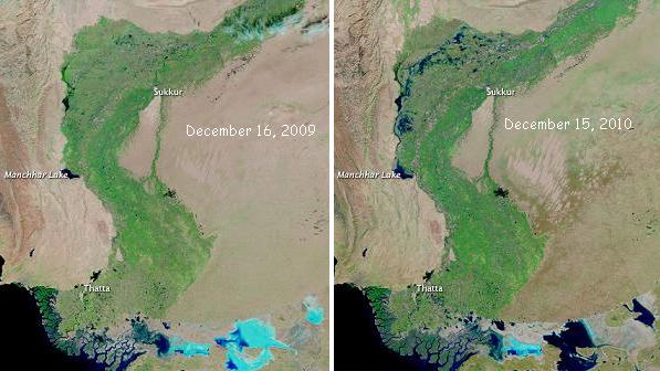
even months after the July floods. But now, there can be no denying the situation. Earth Observatory, a
NASA function, admits that by comparing images from the year before, Pakistan's elevation has sunk.
Period. The Zetas state this drop would be 10 feet, and this 10 foot drop is apparent.
- Lingering Floods in Pakistan
http://earthobservatory.nasa.gov/NaturalHazards/view.php?id=47886&src=nha
- Compared to the image acquired a year earlier, however, the December 2010 image shows
the extent of the lingering floods. Lasting flood damage is also apparent along the coast,
around the city of Thatta. Although the image from December 2010 shows remarkable
improvement over conditions two months earlier, it also reveals persistent pockets of
floodwater that did not exist the previous year.
We are aware that Pakistan has lost elevation, and Thailand at Bangkok likewise cannot get their flood
waters to drain, and Jakarta has been sinking, with land and road along their drainage canals collapsing.
But Vietnam has also been experiencing sinking, as evidenced by an epidemic of sinkholes.

- Viêt Nam:HCM City Explores Sinkhole Mystery
December 22, 2010
http://vietnamnews.vnagency.com.vn/Miscellany/206953/
- HCM City's Union of Science and Technology Association has set up a team to discover
the cause of the sinkholes that have appeared in many locations in the city. So far 59 of the
sinkholes have appeared after first appearing in July. The depressions were a consequence
of the land structure and water in the city. The most important cause was the bogginess of
the land in many places in the country's south-east.
Folding Pacific
We presented this anticipated scenario during the 7 of 10 episodes in Issue 199 of this newsletter on
August 22, 2010, whereby the Marian Trench folds against the Mariana Islands, and then the Mariana
Plate tilts, rising the Mariana Islands slightly. Then the Marian Plate folds against the Philippine Islands,
which are on the rising part of the Philippine Plate. Then the Philippine Plate folds against the tongue
holding Indonesia. Like a deck of cards, being folded, they are all then pulled down as Indonesia sinks.
ZetaTalk Prediction 8/21/2010: It is the pressure from the Pacific that is the issue, as the Pacific
is compressing. Likewise, the Philippine Plate is at issue, as it loses in the compression game and
in essence is pushed under and lost. The Philippine Plate is tipping, rising at the Mariana Islands
and diving under the tongue of the Eurasian Plate that holds Indonesia. This tongue is itself
being pushed down. Imagine the domino effect of the Mariana Trench folding against the
Philippine Plate, tipping this sideways to drive the western edge under the tongue holding
Indonesia, which is at the same time breaking and bending to subduct under the curve of the
Indo-Australian Plate.
In Issue 207 of this newsletter on October 17, 2010, this folding of the Pacific is considered the third
step in the 7 of 10 scenarios, but as the Zetas have stated, the trend is always apparent before major
plate movements occur.
ZetaTalk Prediction 10/16/2010: The sequence of events is, thus:
- a tipping Indo-Australia Plate with Indonesia sinking,
- a folding Pacific allowing S America to roll,
- a tearing of the south Atlantic Rift allowing Africa to roll and the floor of the
Mediterranean to drop,
- great quakes in Japan followed by the New Madrid adjustment,
- which is followed almost instantly by the tearing of the north Atlantic Rift with consequent
European tsunami.
On December 19, 2010 a remarkable lineup of quakes from the Mariana Island to the Philippine Islands
to the northern coastline of Sumatra occurred, showing the pressure on these plates to fold in just the
manner described by the Zetas. Pressure on the Mariana Plate transfers to the Philippine Plate which
transfers to the tongue holding Indonesia!

Pacific Wash
There was no anticipation of gale force winds, cyclones, tropical storms, or any such incident in the days
before high winds and high tides hit the Indonesia region, including the Philippines. High winds were not
predicted for this region. So when high tides and choppy water was reported throughout the Indonesia
region, the question naturally arose - could this be the start of sinking? There was, after all, an outline of
quake all around the tongue holding Indonesia, when the reports first started coming in on December 20,
2010.

- http://www.met.gov.my/index.php?option=com_content&task=view&id=1325&Itemid=564
- Strong Northeasterly winds over 60 kmph with waves up to 5.5 metres occurring over the
waters off Condore and Reef North are expected to continue until 22 December 2010.
-
- 11 Foreign Tourists Rescued in Batanes
December 20, 2010
http://www.mb.com.ph/articles/293946/11-foreign-tourists-rescued-batanes
- A total of 11 foreign tourists consisting of Singaporean, Malaysian, Indonesian and
Australian nationals were rescued by elements of the Philippine Coast Guard after
encountering giant waves while having a kayaking and canoeing adventure along Sabtang
Island in Basco, Batanes.
-
- Storm leaves six dead, 47 missing off Vietnam's coast
Dec 21, 2010,
http://www.monstersandcritics.com/news/asiapacific/news/
- Hanoi - At least six people were killed and 47 missing after last week's strong winds and
rain in the South China Sea off Vietnam. The storm lashed the coast, sinking 26 ships.
But New Zealand and eastern Australia also had high winds and high tides, and this region is not
expected to sink, but rather to rise.
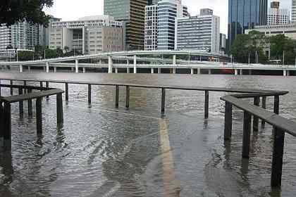
- Australia: Monster tide closes CityCat terminals
December 22, 2010
http://www.brisbanetimes.com.au/environment/weather/monster-tide
- Low-lying areas have been flooded this morning due to an extremely high tide in the
already swollen Brisbane River.
-
- Extreme Weather in New Zealand
21st Dec 2010
http://hisz.rsoe.hu/alertmap/woalert_read.php?glide=ST-20101221-28903-NZL
- Strong winds buffeted Wellington, bringing down trees, trolleybus wires and lifting a
trampoline.
Per the Zetas, it was not sinking land in Indonesia, but a compressing Pacific causing a wash of water
over this entire region. The high tides were blamed on the winds during that time, as a cover-up over the
Earth changes is in place.
ZetaTalk Explanation 12/25/2010: There was clearly a storm, as high winds accompanied the high
tides and high waves. But is there more to the story? Nancy has done some research and
concluded that there seemed to be no warning for the storm. It did not seem to be documented as
a cyclone nor tropical storm, even after it occurred. We stated that sinking in Indonesia would be
covered by claims of high tides and storms, and this is an example though scant additional
sinking occurred on this day. But more occurred. The Pacific plates, which are, as we explained,
not just one but four, compressed, acting as the trigger for the 7.4 quake in Japan. These
compressing plates, one plate sliding under another, force an adjustment in the water above,
which disburses. Thus Australia at Brisbane experienced a high tide, and lands from the
Philippines through Indonesia experienced high waves and choppy water.
You received this Newsletter because you Subscribed to the ZetaTalk Newsletter service. If undesired, you can quickly
Unsubscribe. You can always access prior Newsletters from the Archives.
|

